Between 1985 and 2018, agriculture across Switzerland lost an area roughly twice the size of Lake Geneva: in low-lying areas to new settlements and in the mountains to forest. Recently this trend has even gathered pace. Nevertheless, in 2018 more than one in every three square metres of land continued to be used as agricultural land.
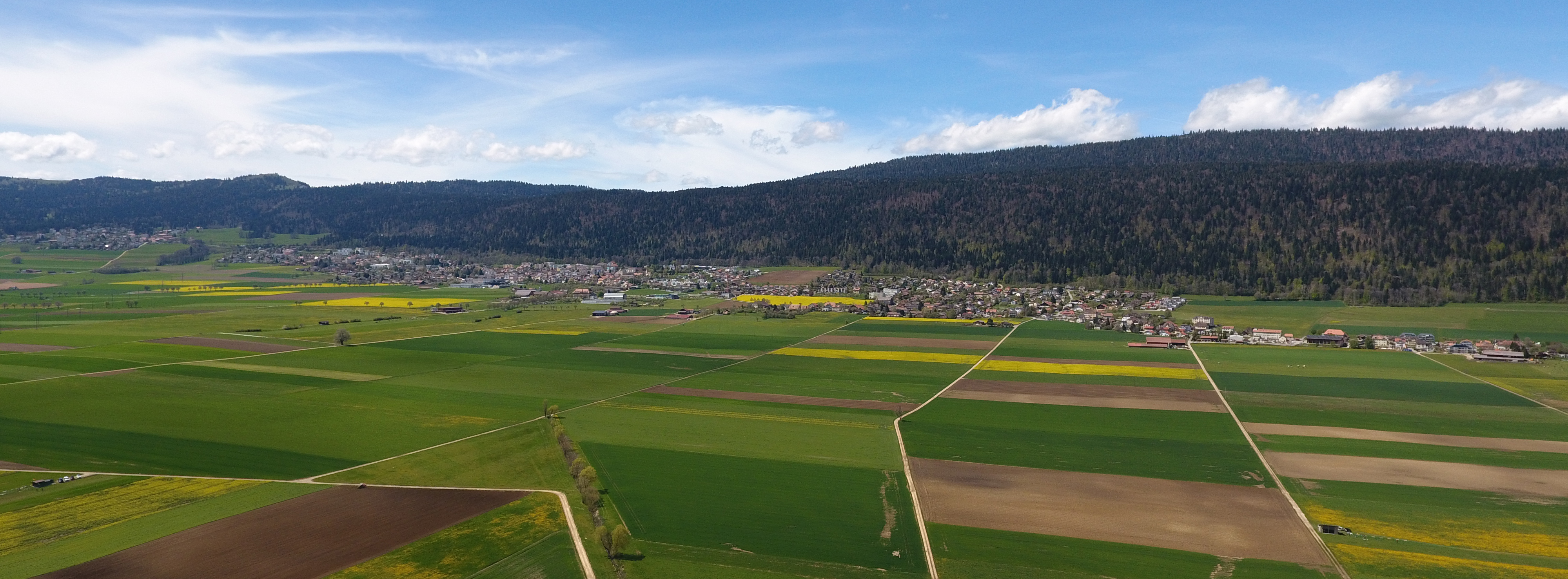
Despite growing pressure from settlements, in large parts of Switzerland the landscape is still shaped by agriculture. With an expansion of 14 535 km2 and a 36% share in Switzerland’s surface area, in 2018 cultivated land represented the largest of the four main categories of land use. According to the Land use statistics, agricultural areas comprise all areas that are used for the commercial production of plant and animal based food. Greenhouses are also included, but household gardens and agricultural buildings such as farmhouses, barns or sheds, which count as settlement and urban areas, are not.
70% of agricultural areas are grass
Large parts of Switzerland are relatively high-lying areas and from an agricultural point of view, due to climate, topography or soil composition, are suited exclusively or predominantly to the keeping of livestock. Consequently, and grassland in the form of natural meadows and farm pastures account for the majority of this cultivated land together with the alpine agricultural area. In 2018 these two types of land use accounted for about a third of the total agricultural area (G22). “Farm pastures” are pastures in permanent settlement areas, i.e. where livestock (excepting the summer period when cattle are in alpine meadows) are usually kept and are thus “on the farm”. At 27%, arable land also accounted for a considerable part of agricultural areas, whereas the share of orchard, vineyard and horticulture areas at 3% was relatively small.

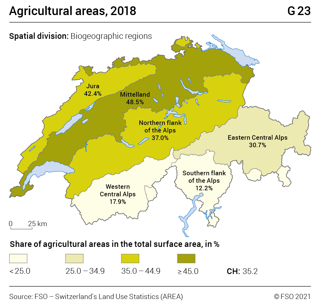
In 2018, in the Mittelland and in the Jura, the percentage of agricultural areas in the total surface area, at 48% and 42% respectively, were higher than the national average. In contrast, in the western Central Alps, at 18% and on the southern flanks of the Alps, at 12%, they are clearly below it (G23).
Switzerland’s arable areas are found almost exclusively (94%) in the Mittelland and in the Jura, where they account for 57% and 31% respectively, of the agricultural area (G24). In the alpine regions, in contrast, cattle farming clearly predominates, with meadows and (alpine) pasture accounting for 88% to 99% of land. Furthermore, in the western Central Alps, orchard, vineyard and horticulture areas are relatively well represented (9%). This is mainly accounted for by the extensive wine-growing area in Lower Valais.

Continuing losses
Between 1985 and 2018 agricultural areas across Switzerland declined by 1143 km2 or 7% (G25). This means that in three decades arable land equivalent to an area roughly twice the size of Lake Geneva was lost – mostly to settlement and urban areas and forests (see below).

The loss of agricultural land was particularly rapid in the observation period 1985-1997: At that time an average of 43 km2 of agricultural area was lost every year in Switzerland (G26). Between 1997 and 2009, at 27 km2 per year, the loss was considerably lower. Changes to agricultural policy probably contributed to this slowing down. Thanks to the instrument of direct payments introduced in 1999 as payment for public and environmental services, farmers were given an incentive to continue farming alpine agricultural areas that had previously been regarded as unprofitable and in some cases to use again areas that had become overgrown. The most recent observations available, however, show that losses have once again gained pace. Between 2009 and 2018 an average of 33 km2 of agricultural area had to make way for other uses, representing an annual loss the size of Lake Brienz.

Particularly sharp decline
in southern Switzerland
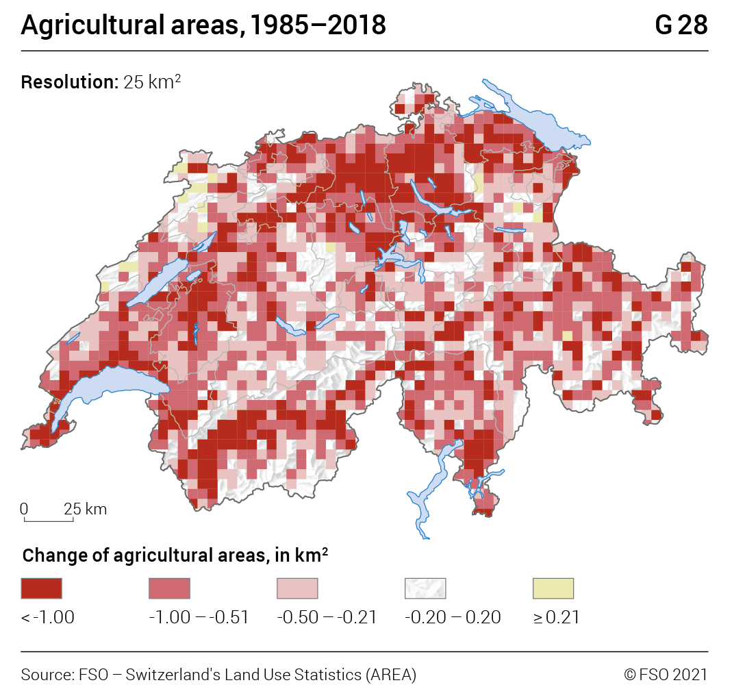
The decline in the agricultural area between 1985 and 2018 concerned all biogeographic regions of Switzerland – but to varying degrees (G27). In terms of percentage, the losses were greatest on the southern flanks of the Alps with –20% and in the western Central Alps with –14%. The Jura and the northern flanks of the Alps, however, with declines of –4% and –5% respectively, were comparatively stable. Losses in the Mittelland, with –8%, were roughly in line with the nationwide mean of –7%. In absolute figures, losses were most marked where the largest reserves of arable land are found, namely in the Mittelland with –450 km2 and on the northern flanks of the Alps with –209 km2. Areas with the most pronounced losses were the Olten-Zurich-Lucerne triangle, the Lake Geneva region as well as Lower Valais and Fribourg region (G28).

Major losses of arable land and orchard,
vineyard and horticulture area
A breakdown of agricultural land lost from 1985–2018 by type of land use shows that – in absolute figures – the decline in arable land with a total of –482 km2 was the greatest (G29, right hand side of the graph). At the same time, the alpine agricultural area showed a loss of 401 km2 and the orchard, vineyard and horticulture area one of 257 km2. For the comparatively small category of the orchard , vineyard and horticultural area, the above-mentioned loss was equivalent to a reduction in the cultivated area of a staggering 35%. This is much greater than the percentage loss of arable land (–11%) and the alpine agricultural area (–7%). The greatest loss in the orchard, vineyard and horticulture area took place between 1985 and 2009; since then the decline has slackened (see G26). The area covered by meadows and farm pastures remained practically unchanged between 1985 and 2018.

What replaces lost agricultural land?
Among agricultural areas that underwent a change in use between 1985 and 2018, and which consequently “disappeared”, just over half (52%) became settlement areas, above all residential areas (22%) (G30). On 30% of repurposed land, new forests and woods grew, 18% became unproductive areas.

Meadows and farm pastures were the most affected by repurposing to settlement areas (358 km2 between 1985 and 2018), followed by arable land (266 km2) and orchard, vineyard and horticulture areas (124 km2) (G29). New forests and woods grew primarily on alpine agricultural areas (280 km2) but also on former meadows and farm pastures (142 km2). Where cultivated land became an unproductive area, mainly alpine agricultural areas were concerned (235 km2). This was mainly alpine meadows and pasture that became grown over with bushes and scrub, which is essentially the first stage of reforestation.
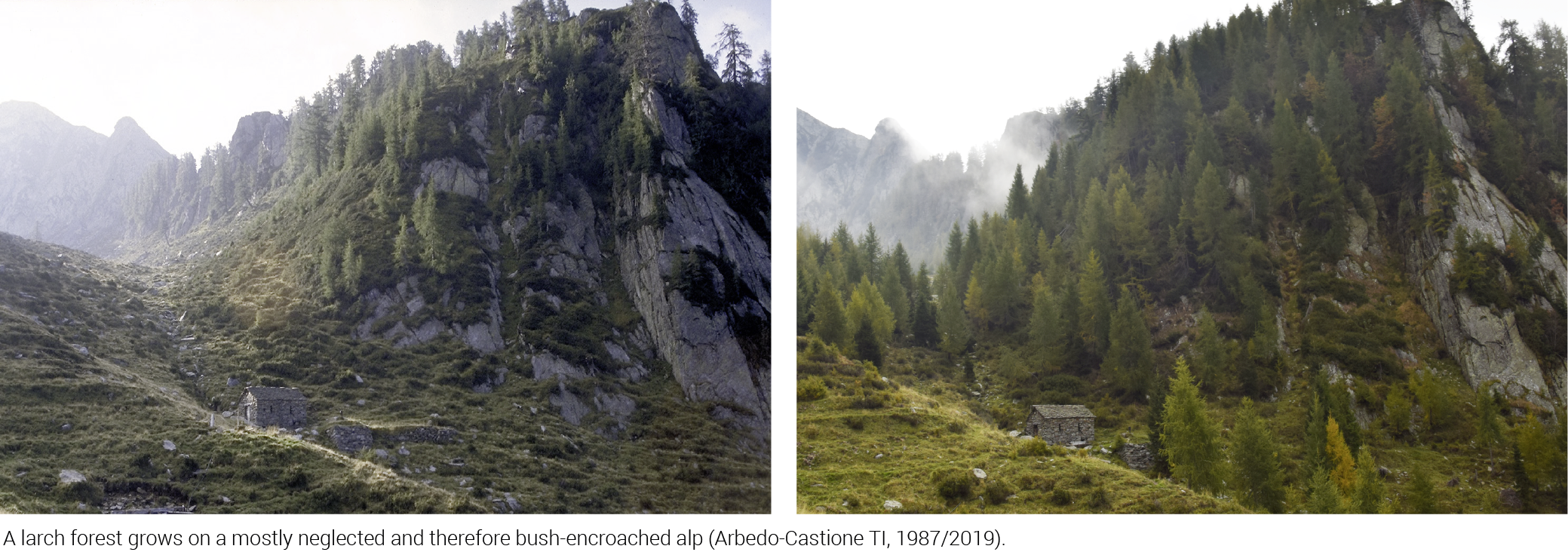
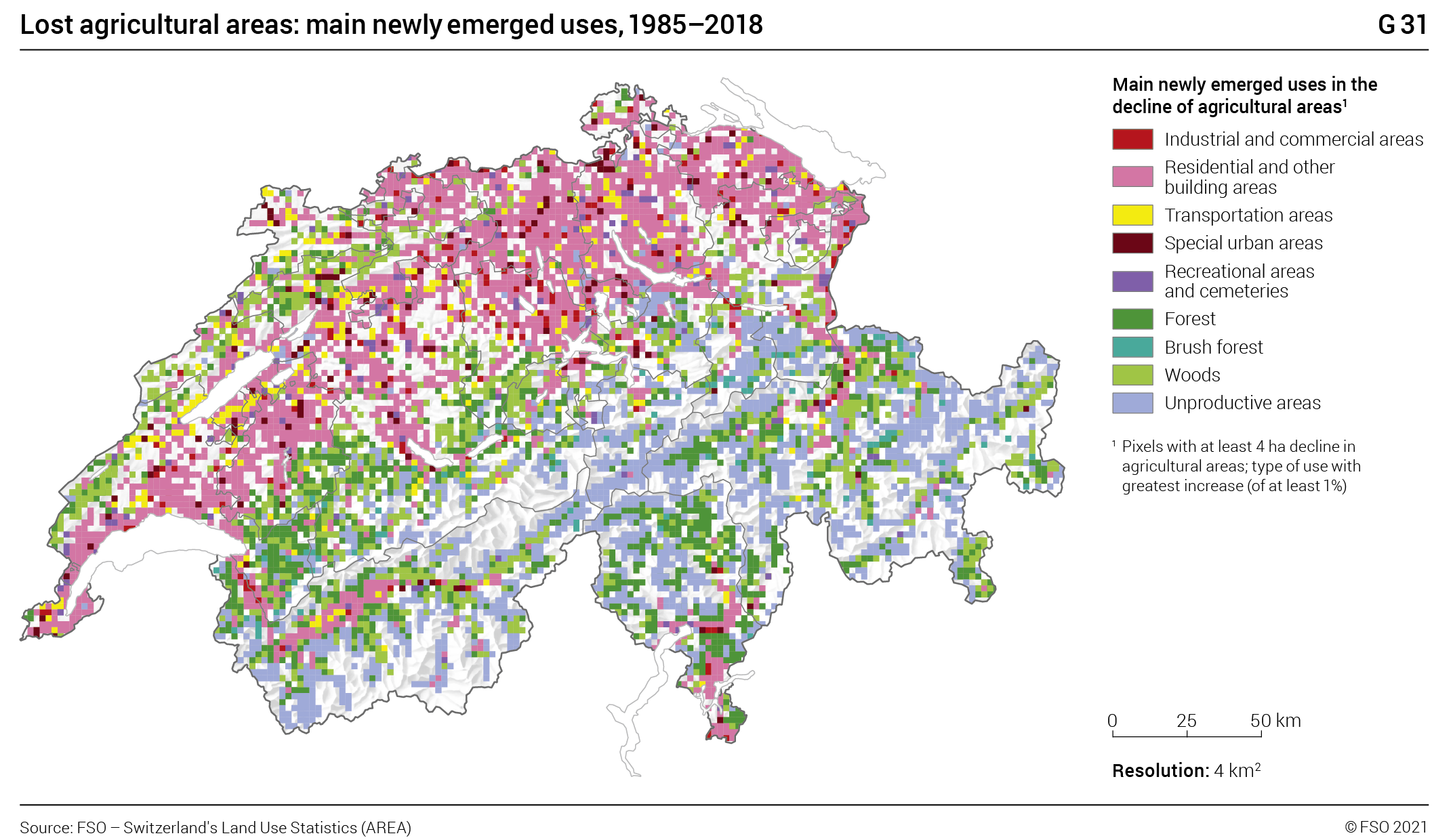
The cartographic representation of the newly emerging uses (G31) shows particularly clearly that a distinction can be made between two – also spatially separated – main forms of cultivated land loss. Whereas agricultural areas in the Mittelland and the valley floors mostly made room for new settlements, in the mountainous alpine regions, scrub encroachment dominates. Where it is no longer profitable, farming of alpine meadows and pastures has been abandoned, resulting initially in the growth of scrub (unproductive vegetation) and later that of woods and forests.
When fields become meadows
– and meadows fields
The fact that agricultural areas, as seen above, have developed very differently depending on the type of use (arable land, meadows/pastures, alpine agricultural areas, orchard, vineyard and horticulture areas) is not only due to a stark repurposing as settlement area or forest. Often, even more decisive are the type and direction of the quite pronounced “internal transfers” of cultivated land between the various agricultural uses (see G29, yellow bars). Overall, in 2018 1100 km2 of agricultural areas was dedicated to a different use type (out of the four use types) than in 1985. At the same time signs of both an intensification and expansion of the agricultural land use could be observed: Mixed crops such as traditional fruit tree orchards were replaced in many places by specialised forms of cultivation and in some areas additional fields, greenhouses, intensive orchards and vineyards bear testimony to more intensive farming. Conversely, many former arable areas are used today for more extensive livestock farming, in particular for suckler cows or horse keeping. The repurposing of arable fields to meadows was particularly marked (following agricultural policy reforms) in the observation period between 1997 and 2009, when the area of meadow and pasture land even increased (G26).
Some places even saw some
new agricultural areas
Contrary to the general trend, in some places, the agricultural area was able to expand between 1985 and 2018 (see G29). Through the clearing of woods, brush forest, woodland pasture and scrub alpine agricultural area, meadows and farm pastures have been re-established in some places. Furthermore, the mild winters of recent years and the consequent early thawing have allowed previously unproductive vegetation to grow more densely at higher levels, rendering it partly usable as pasture and thus repurposing it as agricultural land. At lower altitudes, however, in some places gravel pits,, dumps and large building sites have been closed and the resulting areas then re-cultivated.
Efforts to preserve standard fruit trees bear fruit
As late as the middle of the 20th century, vast standard fruit tree orchards characterised the landscape in many regions of Switzerland – especially in Thurgau, Baselland or around Lake Zug. Their fruit was an important supply of food in winter, stored in the cellar or preserved as dried fruit. Often, an even greater portion of the harvest was fermented and consumed in the form of cider or brandy. In the 1950s however, field fruit areas declined rapidly. There were many reasons for this decline: Some standard fruit tree orchards were replaced by low-maintenance bush fruit trees, others impeded the mechanical cultivation of meadows and fields, and many – because they often stood at the edge of settlement areas – had to make way for new residential and commercial buildings. Often disease led to clearing of trees. In 1985, the first survey year of the modern Land use statistics, there were still 450 km2 of traditional orchards in Switzerland (G32). A quarter of a century later, in 2009, not even half of that was left (221 km2).

Nowadays, however, standard fruit trees are more highly valued again, for scenic and ecological reasons, and the Confederation also encourages their cultivation financially by means of direct payments. Efforts to preserve standard fruit trees seem to be bearing fruit: In the nine years between 2009 and 2018, the area of field fruit trees across Switzerland declined by only 22 km2 to 199 km2 and in many places standard fruit tree orchards have recently been re-established.
Cultivated land under glass and foil:
Greenhouse areas on the rise
Plant cultivation does not only take place under the open sky: Vegetables, lettuces, and berries are increasingly grown in greenhouses in this country too. This type of cultivation makes larger harvests possible and extends the vegetation period, on the other hand it often interferes with the landscape.
The area covered by greenhouses in Switzerland doubled between 1985 and 2018, from 5 to 10 km2 (G33). This figure includes all permanent glass and foil constructions on agricultural areas. Larger, local concentrations of greenhouses are found in the canton of Geneva, in the Seeland region in the cantons of Bern and Fribourg, in the north-west of the canton of Zurich, in the Lake Constance region as well as in Lower Valais and in the Magadino plain.

With the growing pervasiveness of greenhouses and the gradually emerging possibility in the near future of high-tech indoor agriculture (vertical farming), the traditional understanding of agricultural land as freshly ploughed fields and green meadows may one day be out of step with reality. In this event, the categories of the Land use statistics will also need to be adapted to the new circumstances.
